Designing of engineering geodetic works and surveying execution
SERVICES
Surveying sector performs the following work:
Geodetic field surveying and drafting geodetic documentation for the purpose of:
- Preparation of planning documentation;
- Design of industrial buildings and facilities (factories, hydroelectric power, wind power generators, sports grounds, buildings, airports, etc.);
- Design infrastructure systems of all kinds (roads, railways, canals, regulation of rivers, underground installations, power lines, ski slopes, ski lifts, etc.).
Surveying works in engineering:
- Design of all kinds of geodetic networks;
- Monitoring and marking on the ground during the construction of residential and industrial buildings, tunnels, bridges, dams and infrastructure systems of all types (streets, roads, railways, canals, power lines);
- Control of geometry of objects;
- Deformation analysis of engineering structures;
Geodetic works on the formation and maintenance of real estate cadastre and maintain survey and cadastral underground lines
Supervision over all kinds of geodetic works
Preparing and maintenance of geographic information systems (GIS):
- Data entry, database organization, automatic data processing, analysis and reporting, display of data in the geographic information system (GIS);
- Working with GIS solutions according to the needs of the users of the alphanumeric database and adapting to the request of the users of services;
- Organizing geospatial databases;
FOCUS
Within the listed activities, we must pay special attention to the following:
- Respecting the interests of designers and investors
- Professionally and conscientiously carry out surveying works
- Cooperation with experts in the field of interest
- This depth and quality of the performed geodetic works
- Monitoring of latest technical and scientific developments and the use of modern equipment and modern software tools in the performance of all kinds of geodetic works
- Respect deadlines, in accordance with the schedule of works
REFERENCES
_______________________________________________________________________________
MERIDIJANPROJEKT
SURVEYING AND DESIGN – Branch in Novi Sad
ROAD SECTOR
Venac Stepe Stepanovica 22, 25 000 Sombor, Serbia
Phone: 025/415-800;
Phone/Fax: 025/420-581
E-mail: mprojekt.sombor@gmail.com
Working hours:
Weekdays: 07:00-14:30h
Saturday: Closed
SURVEYING AND DESIGN – Belgrade branch
ROAD SECTOR
Ustanicka 189, lokal 15, TC Konjarnik, 11 000 Beograd
Phone #1: 011/347-0100;
Phone #2: 011/289-5610
E-mail: office@meridijanprojekt.com
Working hours:
Weekdays: 08:00-16:00h
Saturday: Closed
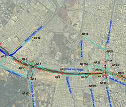
Geodetic surveying, analytical processing and defining road zone in terms of road chainage, L=2150 km
2014-2015
Autonomous Province of Vojvodina, Republic of Serbia
PE “Putevi Srbije” Belgrade
Complete surveying works for double line city street 5 New City – Al Hshashah, L=27.497km
2014
Libya, Zintan
Ministry of Transportation, Authority for Roads, Bridges and Lands Transportation
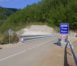
Developing expropriation projects for access roads to the facilities on the magistral pipeline “Južni tok”
2014
Republic of Serbia, from the state border with Bulgaria to the state border with Hungary
Institute for Water Management “Jaroslav Černi” Belgrade
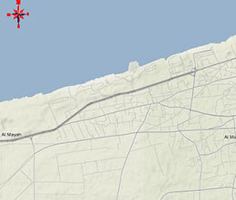
Complete surveying works for improving, upgrading and equipping coastal road Ra’s Jdeir – Emssaed, L=1860 km
2010-2014
Libya, Ra’s Jdeir
Ministry of Transportation, Transportation project board, Tripoli
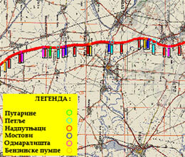
Surveying works for double line and high-way design, L= 4000 km.
2006-2011
Libya
Secretariat of communication and transport Department of Road and Bridges, Tripoli
Geodetic surveying, analytical processing and defining road zone in terms of road chainage, L=621 km
2006-2011
Autonomous Province of Vojvodina, Republic of Serbia
Vojvodinaput – Bačkaput AD Novi Sad